Count values in multi-valued columns
Let's suppose we have a dataset of research studies conducted in various states, and we want to map how many studies took place in each state. The tricky part is that some studies are associated with multiple states, and so our studies table may look something like this:
| id | title | place |
|---|---|---|
| 1 | Study one | Ohio |
| 2 | Study two | Virginia; Ohio |
| 3 | Study three | West Virginia; Ohio |
| 4 | Study four | Ohio; West Virginia;Delaware |
In this example, we have used semicolons to delimit the mulitple values. We chose semicolons instead of commas, just to avoid any potential problems when using the CSV file format. Also note that there are semicolons with and without a space following. The method below will handle both varieties.
The count of total studies by state should look like this:
| place | total |
|---|---|
| Delaware | 1 |
| Ohio | 4 |
| Virginia | 1 |
| West Virginia | 2 |
1. Create a virtual layer
Virtual Layers is a QGIS feature that allows us to write an SQL query to dynamically compute a new table or layer. We can use it to run a query that will create the table of placename totals and automatically join those totals to state polygons from an existing layer. The following query assumes that we have a polygon layer called states that includes a column called name.
- From the Layer menu, select "Create Layer > New Virtual Layer…"
- Set the Layer name to "state_totals"
- Enter the following SQL query:
with temp as (
    with recursive splitvalues(id, val, more) as (
        select id, '', replace(place, '; ', ';') || ';'
        from studies
        union all
        select id, substr(more, 0, instr(more, ';')), substr(more, 1+instr(more, ';'))
        from splitvalues
        where more <> ''
    )
    select trim(val, '; ') as place, count(*) as total
    from splitvalues
    where val <> ''
    group by val
    order by val
)
select temp.place, total, st_centroid(geometry) as geometry
from temp left join states on temp.place=states.name
- Expand the Geometry section of the dialog, and set:
- Geometry column = geometry
- Type = Point
- Click the "Add" button
- If you are prompted to select a CRS, choose the same CRS of your states polygons
This should add a new layer called "state_totals" to your project. Note that, by using a "left join", this layer only includes places that are listed in the studies table, and the output layer contains just the centroid points of the corresponding states. We do this to make it easier to visualize the data on the map using point styles, which can make it easier to see the data for smaller states like Delaware, for example.
2. Style the points
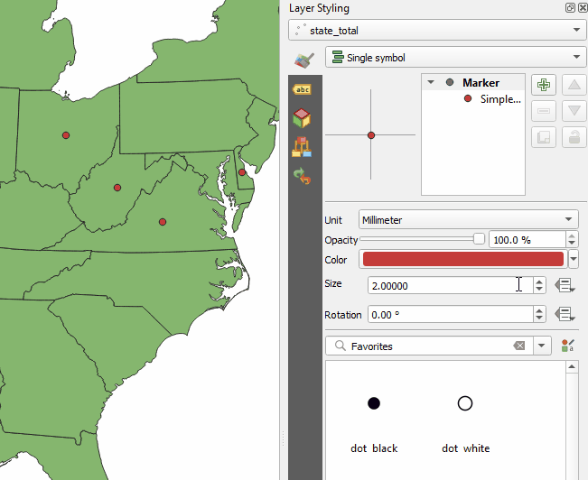
To size the state points proportionally by the total number of studies for that state, we can set a data-defined override for the point size, using the following expression:
sqrt("total")*8
Note that we use the square root so that the area (not the radius) is proportional to the value. And multiplying by 8 sets the base size for a value of one. The expression would need be adjusted to handle larger numbers. If you want help writing an expression, see the "Assistant" option in the drop-down menu for the data-defined override button.
Note
The SQL query above includes some recursive magic that helps to split the values as many times as necessary for all the semicolons. Many thanks to Samuel Bosch's original recipe, which we modified to split on semicolons with or without a following space, and to remove any trailing punctuation from the final output.